San Antonio - Canyon Lake
-
Time: approx 1.5 hours
-
Distance: 1.5 mile (round trip)
-
Cost: Starting at $59.99 Per Adult
-
Weight Restrictions: 400 pounds per boat (two guests) per manufacturer specifications, The maximum weight limit of a single person may not exceed 250lbs.
-
Location: 579 Skyline Dr, Canyon Lake, TX 78133
-
Reservations:
Regular Reservations:
Required at least 24 hours in advance.
Same-Day Reservations:
Available with a 20% convenience fee.
(This is a guided tour in a clear kayak, so be sure to secure your spot ahead of time!) -
When: Sundays at 8:30pm and 11:00pm
Book Now
Route Description
Canyon Lake, located in the picturesque Texas Hill Country, is not only a popular recreational destination but also a site rich in history and natural beauty. Created by the damming of the Guadalupe River in the mid-20th century, Canyon Lake offers visitors a unique blend of outdoor activities, stunning scenery, and glimpses into the past.
The story of Canyon Lake begins in the 1950s when the U.S. Army Corps of Engineers constructed the Canyon Dam as part of a flood control and water conservation project. Completed in 1964, the dam not only served its intended purposes but also resulted in the formation of the reservoir known as Canyon Lake. Spanning over 8,200 acres and boasting a shoreline of approximately 80 miles, the lake quickly became a haven for water sports enthusiasts, anglers, and nature lovers alike.
However, beneath the tranquil waters of Canyon Lake lies a fascinating secret: the remnants of several sunken cities. These submerged settlements date back to the mid-19th century when the area was inhabited by early settlers, primarily German immigrants drawn to the promise of fertile land and abundant natural resources.
One of the most notable sunken cities is that of "Cranes Mill." Established in the 1850s, Cranes Mill was a thriving community situated along the banks of the Guadalupe River. It boasted a gristmill, general store, and a handful of residences, serving as a hub for local commerce and trade. However, the construction of the Canyon Dam spelled the demise of Cranes Mill, as the rising waters of the reservoir ultimately submerged the once-bustling town beneath the lake's surface.
Another sunken city of note is that of "Hancock." Named after its founder, James C. Hancock, this settlement flourished in the mid-19th century as a trading post and stagecoach stop. With its strategic location along the Old Blanco Road, Hancock became a vital waypoint for travelers journeying through the Texas Hill Country. Yet, like Cranes Mill, Hancock met its fate with the completion of the Canyon Dam, consigning the town to a watery grave.
Despite their submerged status, these sunken cities continue to capture the imagination of historians, archaeologists, and curious visitors alike. Divers frequently explore the depths of Canyon Lake in search of artifacts and clues about the lives of those who once called these lost communities home. Additionally, the receding waters of the reservoir occasionally reveal glimpses of the past, offering tantalizing glimpses of forgotten structures and relics.
In addition to its historical significance, Canyon Lake is renowned for its stunning natural beauty. Nestled amidst rolling hills and rugged limestone cliffs, the lake offers breathtaking vistas and abundant opportunities for outdoor recreation. Visitors can enjoy boating, fishing, hiking, camping, and wildlife viewing, making it a year-round destination for adventure seekers of all ages.
In conclusion, Canyon Lake, Texas, is much more than just a reservoir—it's a treasure trove of history, culture, and natural wonders. From its origins as a flood control project to its emergence as a premier recreational destination, the lake's story is as deep and complex as its waters. And with the remnants of sunken cities lurking beneath its surface, Canyon Lake continues to captivate and inspire all who dare to explore its depths.
Directions & Parking
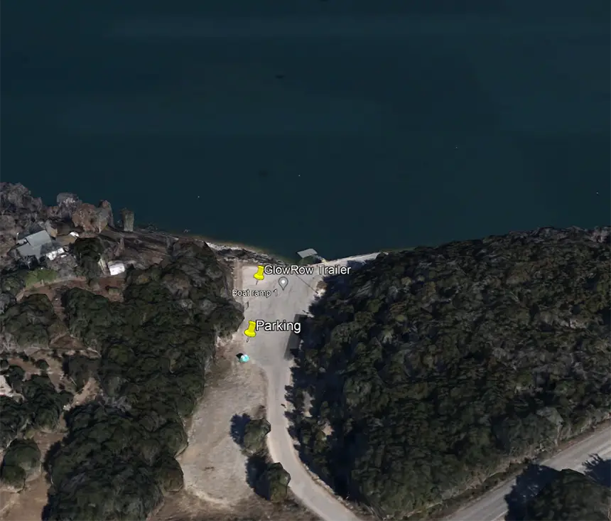
To find your way to this launch spot, simply put in the below address on your phone's GPS and look for the GlowRow® Trailer!
Parking for this area is free in the indicated parking areas (see map image).
Closest Physical Address
579 Skyline Dr, Canyon Lake, TX 78133
GPS Coordinates
